Quantcast
Channel: Environment
Viewing all 2972 articles
Browse latest View live

Tropical Storm Irma is gaining attention as it moves across the Atlantic — and could become a hurricane by Friday

$
0
0

Tropical Storm Irma

Texas and parts of Louisiana are still dealing with catastrophic flooding from Harvey, which is still dumping rain in many areas. But forecasters are also starting to keep an eye on a new storm that may become the next threat: Tropical Storm Irma.

The National Hurricane Center on Wednesday declared Irma the season's ninth named storm. The NHC is projecting that the storm could intensify to hurricane status by Friday morning, though it's still too soon to know whether it'll pose a threat to anyone in the Caribbean or the US.

The big question is where Irma will go. It's in the eastern Atlantic, moving west at 10 to 15 mph. When it reaches the Antilles in the eastern Caribbean next week, researchers will be watching its path.

Most storms that turn north before they hit the Antilles wind up curving away from the US, according to Brian McNoldy, a cyclone researcher. But if Irma passes over the islands or goes south of them, as some models predict, it could become a threat for locations in the Caribbean, Mexico, or the US.

This is the first time Irma has been used as a name for a storm. Storm names are selected from an alphabetical, recurring list, but a name is retired if it becomes associated with a particularly devastating weather event. Irma replaced the name Irene after the 2011 hurricane with that name caused widespread destruction in the Caribbean and the US.

We'll know more about Irma by the middle of next week, according to McNoldy.

Meanwhile, another potential tropical disturbance could form in the Gulf of Mexico next Tuesday or Wednesday, he wrote. If that happens, that storm could be headed for the already drenched Texas and Louisiana coasts.

SEE ALSO: Hurricane Harvey was ‘almost certainly’ more devastating because of human-caused warming

Join the conversation about this story »

NOW WATCH: China is spending $168 million on weather-controlling technology


Flash floods send Texans into 'survival mode' as Harvey hits Port Arthur with 26 inches of rain in one day

$
0
0

Hurricane Harvey Rainfall Map BI Graphics weds afternoon

Harvey's catastrophic flooding moved east of Houston on Wednesday as the storm continued through southeastern Texas into Louisiana.

Over 26 inches of rain were recorded at the airport near Port Arthur, a city located about 90 miles east of Houston in Jefferson County, on Tuesday alone. The rainfall triggered flash flooding that many residents of the area were desperate to escape.

The Bowers Civic Center, where at least 100 people had sought shelter after their homes flooded, was inundated with water early Wednesday morning. Evacuees were forced to abandon floating cots and retreat to the bleachers lining the building.

Other shelters have since opened in the city to accommodate the approximately 3,000 evacuees who needed a place to stay.

Port Arthur mayor Derrick Freeman told CBS News that 20,000 homes had as much as 6 feet of water in them. Jefferson County Deputy Sheriff Marcus McLellan said 911 operators had gotten overwhelmed with requests and residents were in "survival mode."

Freeman posted on Facebook Wednesday afternoon that the US Coast Guard, local first responders, and volunteers had more than 150 boats out rescuing people.

"Our whole city is underwater right now but we are coming! If you called, we are coming,"Freeman posted on Facebook early Wednesday morning. "Please get to higher ground if you can, but please try stay out of attics."

Check in #PortArthurTexas

Posted by Derrick Freeman on Wednesday, August 30, 2017

The Port Arthur city Twitter account encouraged residents to "display a white towel, sheet, shirt or anything" so rescuers could find them in the torrential rain, which was still pouring down Wednesday afternoon.

Hal Needham, a hurricane scientist at Louisiana State University, estimated in a blog post that the triangle of Port Arthur and Beaumont in Jefferson County and Orange in the neighboring Orange County was getting as much as 6 inches of rain an hour. The Weather Channel reported that Port Arthur was receiving up to 3.87 inches an hour.

"I promise I am not exaggerating when I say at least hundreds, if not thousands, of people are fighting for their lives right now," Needham wrote Wednesday morning.

People in the area posted hundreds of messages on Facebook and Twitter requesting rescue:

Freeman said multiple fires broke out Tuesday night, and the Port Arthur Fire Department lost three firetrucks in the carnage.

Officials closed the I-10 highway from Houston to New Orleans because the floodwaters were so high. And the Motiva oil refinery in Port Arthur, the largest in the US, was forced to shut down because of the flood, CNN reported.

Livestock were also caught in the floodwaters, and the Texas Department of Transportation posted a harrowing video of cattle running down a flooded highway:

"We aren't hearing these people crying out because they have no voice," Needham wrote. "Many have lost power, in the best case have made it to a roof. The eyes of the world are on Houston and these smaller cities in southeast Texas are crying out and nobody can hear them."

The rain in Port Arthur should let up by Wednesday night.

"Continue to pray for us; lift us up," Freeman said in a Facebook live video Wednesday afternoon, adding, "We're tough. We're going to rebuild. We're going to bounce back even stronger than we were before."

SEE ALSO: Harvey makes 2nd landfall on Louisiana border after pummeling Texas with 'catastrophic' flooding — here's the latest

DON'T MISS: Full Harvey coverage here

Join the conversation about this story »

NOW WATCH: Here's how to escape a flooding vehicle

Aerial footage of Houston captures the catastrophic scale of Hurricane Harvey

$
0
0

harvey flooding homes texas

With winds topping 130 mph and downpours reaching four inches per hour, Hurricane Harvey made landfall on Texas' Gulf Coast on Friday night. Since then, it has killed at least 31 people, damaged or destroyed approximately 20,000 homes, and displaced tens of thousands.

It's set to be one of the worst natural disasters in US history, and it's not even over. Harvey just made second landfall in Louisiana, and several counties in the Houston and New Orleans area are under flash flood watch until Thursday evening.

Marco Luzuriaga, a photographer based in Houston, captured the ongoing devastation in the city with a drone.

On August 27, the drone flew over Brays Bayou, a river in Harris County, where rainfall has measured as high as 51 inches. As you can see below, Harvey has submerged the majority of buildings in the area:

Several other people have posted drone footage of the affected areas, including Port Arkansas, Rockport, and League City in Texas. Gizmodo did an extensive roundup of these videos if you'd like to check out more.

If you'd like to help those affected, there are lots of food banks and charities, both local and large-scale, raising money for Harvey relief. Before giving, it's a good idea to research the reliability of these organizations. 

Harvey could cause $48 billion to $75 billion in damage, Enki Research estimated. When Hurricane Katrina hit New Orleans and the Gulf Coast in 2005, it led to over $100 billion in damage. Aerial footage is one way to document the wreckage.

SEE ALSO: How the devastation of Hurricane Harvey compares with Hurricane Katrina

Join the conversation about this story »

NOW WATCH: Here's the best way to watch the solar eclipse if you don't have special glasses

Watch US Navy sailors airlift stranded Texans during intense flooding from Hurricane Harvey

Oil refineries may have released up to 2 million pounds of chemicals in Harvey's wake

$
0
0

Hurricane Harvey Corpus Cristi oil refinery

Tropical Storm Harvey may be on the move — but its after-effects are just beginning to be realized.

In addition to slamming homes and hospitals, the storm struck the heart of Texas' refining industry, where roughly a third of America's oil is processed. In its wake, more than two million pounds of hazardous chemicals have been released into the air, according to filingsreportedwith the Texas Commission on Environmental Quality and first reported by Politico.

Those chemicals include cancer-causing and potentially lethal gases like carbon monoxide and benzene, among others.

Shortly after Harvey made landfall, companies including Exxon Mobil and Valero Energy began to shutter local facilities and evacuate workers, taking close to a fifth of the nation's total refining capacity offline.

Yet those efforts failed, in many cases, to prevent the release of hazardous pollutants into the environment.

Oil Tank Hurricane HarveyIn some cases, companies were forced to intentionally burn chemicals as a means of disposing them in anticipation of the storm. Chevron Phillips, the company that reported the largest release, burned close to 800,000 pounds of chemicals — nearly 300,000 of which were the colorless, odorless, and potentially deadly gas carbon monoxide— as it shuttered its plant to prepare for Harvey.

At other plants, Harvey's rising waters easily overwhelmed existing safety precautions.

At Exxon's Baytown plant, the floating roof covering one tank "partially sank during the excess rain event" from the storm, it noted in a TCEQ filing showing that close to 13,000 pounds of chemicals — including cancer-causing benzene and toxic lung-irritant xylene — had been released. Similarly, officials at Kinder Morgan's Pasadena terminal, which released close to 300,000 pounds of chemicals, noted in a filing that several floating roof tanks were "impacted by torrential downpour" from Harvey.

Wei-Chun Chin, a professor of engineering at the University of California, Merced who has contributed research on the after-effects of oil spills like Deepwater Horizon, told Business Insider that although the immediate effects of these pollutants on the air sound concerning, he is more worried about the potential for some of those chemicals to stick around.

"I’m more concerned about things that could have a lingering effect and stay in the soil," said Chin. "Benzene is a known carcinogen. So if that's coming back into the ground that would be very bad."

Still, Chin said that researchers' ability to get accurate numbers on these pollutants is very limited right now.

"In many of these areas, the air monitoring stations are suspended. With no measurement we just don’t know the concentrations," he said.

TCEQ is delaying any response to the leaks until flood waters have receded, according to a statement.

"In an ongoing emergency response, the TCEQ and other state agencies give priority to protecting and preventing imminent threats to public health," the statement reads. "Once flood waters have receded, and it is safe to enter flooded areas, debris removal activities will commence. The TCEQ is aware that spills occur during flooding events, and the appropriate primary agency will monitor and work with the responsible party, if known, to take appropriate actions as conditions allow."

Exxon-Mobil did not respond to a request for comment.

SEE ALSO: Health officials are warning Texans to stay out of Harvey floodwaters for a disturbing reason

DON'T MISS: Rains from Hurricane Harvey broke 60 years of US continental records — here's why

Join the conversation about this story »

NOW WATCH: An expanding sinkhole in Florida has swallowed 7 homes

Explosions at Houston chemical plant after it was flooded by Harvey

$
0
0

harvey houston flooding

  • There were two explosions at Arkema chemical plant near Houston, Texas, after Hurricane Harvey flooding.
  • 15 police officers were taken to hospital for inhaling fumes, while a 1.5-mile evacuation perimeter remains in place.
  • There's a risk of more explosions as officials plan to allow the fire to burn out.
  • The incident wiped 100 million euros ($118 million) off Arkema's market value.

Explosions have been reported at a chemical plant near Houston, Texas, which was hit by flooding in the aftermath of Hurricane Harvey.

The Arkema plant in Crosby, Texas, is about 25 miles (40 kilometers) northeast of Houston. It lost power and its backup generators amid Harvey's deluge, leaving it without refrigeration for chemicals that become volatile as the temperature rises.

Arkema

Arkema, the French company that owns the Crosby plant, confirmed on Thursday morning that it was made aware of the explosions by the local emergency operation, Harris County Emergency Operations Center.

In a statement, the company said the explosions were reported at 2 a.m. local time (CDT) and an evacuation zone of 1.5 miles remains in place around the plant.

Police and fire services have also imposed a no-fly zone around the area, which extends to drones. It means media are unable to get an aerial shot of the plant.

The National Weather Service Houston tweeted this warning:

This was what the plant looked like before the fire:

The Harris County Sheriff's Office's tweeted that 15 police officers had been taken to the hospital after inhaling fumes from the chemical plant. Thirteen of these had been released and two were still being assessed.

KPRC 2 Houston reported that some of the officers were complaining of "headaches, dizziness" after the explosions. But Harris County Sheriff Ed Gonzalez told reporters that the fumes were not toxic and were similar to "standing over a burning campfire." There are no reports of other injuries.

The fire service downplayed the size of the explosions. Bob Royall, assistant chief of the Harris County Fire Marshal's Office, preferred the term "container ruptures" when addressing reporters on Thursday. "I don’t want the public thinking these are massive explosions," he said, in a press update that was streamed on Periscope.

Video from local TV station KHOU showed an eerie glow from the fire. The media is being kept back 1.5 miles from the scene:

Arkema said there was a risk of more explosions.

"We want local residents to be aware that product is stored in multiple locations on the site, and a threat of additional explosion remains," the company said. "Please do not return to the area within the evacuation zone until local emergency response authorities announce it is safe to do so."

Earlier on Thursday morning, an Arkema spokeswoman said the fire will "resemble a gasoline fire" and will be "explosive and intense in nature." The spokeswoman agreed with local officials that the "best course of action is to let the fire burn itself out."

The news has wiped $118 million off Arkema's market value. Shares listed on Euronext are down 2.1% at lunchtime on Thursday.

The plant is not located in a heavily populated area.

Arkema map

It looks as if one of hundreds of tank farms that dot the Texas landscape.

Arkema Texas

This is a view of the plant from near the front gate:

Arkema plant

SEE ALSO: Oil refineries may have released up to 2 million pounds of chemicals in Harvey's wake

Join the conversation about this story »

NOW WATCH: Pilots flew straight into Hurricane Harvey and caught this incredible first-hand footage

This satellite photo of Harvey's flooding reveals the scope of the disaster from space

$
0
0

deimos 1 2 satellite illustration earth airbus deimos imaging urthecast

Eastern Texas saw its first rays of sunshine in days on Wednesday. Deadly floodwaters there left by Hurricane Harvey and its stormy remnants are finally beginning to recede.

The open skies gave residents in Houston — an area devastated by record-breaking rainfall and flooding— their first sign of hope for recovery, and also allowed satellites in space clear views of the devastation.

Deimos-1 and Deimos-2, a pair of satellites run by Deimos Imaging (a subsidiary of UrtheCast), have started beaming back their first images of Harvey flooding.

Drag the slider on the interactive below to compare before-and-after images.

The left pane shows a Google Earth image dated to January 2017, and the right pane is an image of the same area taken by Deimos-2 on Wednesday.

Near-infrared light detected by the satellite and processed in this image makes plants look red and water look green-blue. This boosts the image's contrast and helps flooding look more clear set against the vegetation and lingering clouds.


The images show Interstate 69 near Humble, Texas, which is located northeast of Houston. Both cities are part of Harris County, one of the regions hardest-hit by flooding.

A swollen tributary of Lake Houston can be seen overtaking a bridge to the north. Nearby neighborhoods and businesses also appear swamped by floodwaters.

The company hopes to take clearer images of the region in the days to come.

SEE ALSO: Catastrophic flooding continues as Harvey moves northeast, causing explosions at a Texas chemical plant — here's the latest

DON'T MISS: The crucial reason Houston officials didn't order evacuations before Harvey made landfall

Join the conversation about this story »

NOW WATCH: Pilots flew straight into Hurricane Harvey and caught this incredible first-hand footage

There's a scientific reason why a chemical plant exploded after Harvey — and it means more blasts are likely

$
0
0

ct texas chemical plant harvey 20170831 001

  • The Arkema chemical plant near Houston, Texas, exploded after it was flooded by Tropical Storm Harvey.
  • The plant produces compounds which can become explosive when left un-refrigerated.
  • Harvey's floodwaters knocked out power and backup generators, disabling the refrigeration.
  • 15 police officers were taken to the hospital for inhaling fumes and a 1.5-mile evacuation perimeter is in place.
  • Officials plan to allow the fire to burn out, so there is a risk of further blasts.

Explosions were reported on Thursday morning at a chemical plant near Houston, Texas, which was hit by flooding in the aftermath of Tropical Storm Harvey.

The blasts came less than 24 hours after the plant's North America chief executive said that the company had no way of preventing chemicals from catching fire or exploding after heavy floods inundated the region and swamped the site with six feet of floodwater.

ArkemaThe Arkema plant in Crosby, Texas (roughly 25 miles northeast of Houston) produces organic peroxides used to make plastic. The compounds are known to be explosive. Amid Harvey's deluge, Arkema lost power, leaving the chemicals un-refrigerated and prone to becoming volatile as they warmed.

Because the chemicals remain un-refrigerated, authorities warned that further blasts are likely.

"The concern is that when these things degrade they generate heat. When they generate heat, they can burn. When they burn, if they burn aggressively, you can have an explosion," Richard Renner, an Arkema executive, told CBSN on Thursday morning in a video posted to Twitter.

The plant was fined nearly $110,000 in February by the Occupational Safety and Health Administration over 10 safety violations, The Associated Press reported.

Other chemical plants, including multiple oil refineries, have also faced chemical leaks in Harvey's wake. According to filingsreportedwith the Texas Commission on Environmental Quality, more than two million pounds of hazardous chemicals have been released into the air.

Arkema confirmed on Thursday morning that it was made aware of the explosions by the local emergency operation, Harris County Emergency Operations Center.

In a statement, the company said the explosions were reported at 2 a.m. local time (CDT) and an evacuation zone of 1.5 miles remains in place around the plant. Police and fire services have also imposed a no-fly zone around the area, which extends to drones. 

Smoke streaming from the facility irritated the eyes and throats of more than a dozen law enforcement officers near the scene, Harris County Sheriff Ed Gonzalez told NBC.

"It's basically like standing over a barbecue pit or something like that, where you get smoke in your eyes," he said.

The National Weather Service Houston tweeted this warning:

This was what the plant looked like before the fire:

The Harris County Sheriff's Office's tweeted that 15 police officers were taken to the hospital after inhaling fumes from the chemical plant. Thirteen were released, while another two are still being assessed.

KPRC 2 Houston reported that some of the officers were complaining of "headaches, dizziness" after the explosions. But Harris County Sheriff Ed Gonzalez told reporters that the fumes were not toxic and were similar to "standing over a burning campfire."

There are currently no reports of other injuries.

The fire service downplayed the size of the explosions. Bob Royall, assistant chief of the Harris County Fire Marshal's Office, used the term "container ruptures" when addressing reporters on Thursday. "I don’t want the public thinking these are massive explosions," he said, in a press update that was streamed on Periscope.

Video from local TV station KHOU showed an eerie glow from the fire. The media is being kept back 1.5 miles from the scene:

Arkema warned about the risk of further explosions.

"We want local residents to be aware that product is stored in multiple locations on the site, and a threat of additional explosion remains," the company said. "Please do not return to the area within the evacuation zone until local emergency response authorities announce it is safe to do so."

Earlier on Thursday morning, an Arkema spokeswoman said the fire will "resemble a gasoline fire" and will be "explosive and intense in nature." The spokeswoman agreed with local officials that the "best course of action is to let the fire burn itself out."

The news has wiped roughly $92 to $118 million from Arkema's market value. Shares listed on Euronext are down 2.1% on Thursday afternoon.

The plant is not located in a heavily populated area.

Arkema map

It looks like one of hundreds of tank farms that dot the Texas landscape.

Arkema Texas

This is a view of the plant from near the front gate:

Arkema plant

SEE ALSO: Oil refineries may have released up to 2 million pounds of chemicals in Harvey's wake

Join the conversation about this story »

NOW WATCH: Why planes leave white trails in the sky — and how you can use them to predict the weather


Texans face a 'triple threat' from insects, mold, and bacteria in Harvey's wake

$
0
0

harvey flood houston rescue evacuation

Tropical Storm Harvey may be on the move — but its after-effects are just beginning to be realized.

In under a week, the storm unleashed as much as 51 inches of water in some areas, causing catastrophic flooding that displaced 33,000 Texans. At least 41 people have died since the storm began, and officials expect the toll to rise.

People in flooded areas quickly found themselves face-to-face with a range of health problems, including contaminated floodwaters and the threat of injury.

Although the skies have begun to clear, the problems are far from over. See what people in affected areas are up against for the next several months:

SEE ALSO: Health officials are warning Texans to stay out of Harvey floodwaters for a disturbing reason

DON'T MISS: Heartbreaking photos show Houston's devastating flooding from the sky

Mosquitoes gather near standing floodwaters, spreading infection.

While the storm wiped out mosquitoes from the area for now, the standing water left over from the flooding and the warm temperatures will make parts of Texas particularly prone to mosquitoes and the diseases they can carry in the coming months and year.

"As the floodwaters recede, you’re left with pockets of water which are good for breeding both Culex mosquitoes and Aedes mosquitoes," Dr. Peter Hotez, dean of the National School of Tropical Medicine at Baylor College of Medicine in Houston, told The Atlantic. That could lead to more West Nile infections, and possibly Zika. Texas has seen some local transmission of Zika in Brownsville, Texas near the Mexico border. 


Chemical plants sent offline by the storm explode or burn, releasing harmful pollutants.

Explosions rocked the outskirts of Houston on Thursday at the Arkema chemical plant after flooding shut down its power and backup generators, which had been keeping explosive compounds cool via a refrigeration system.

When the refrigerators went offline, the compounds got warm and exploded. Officials said they plan to let the fire burn out, meaning more blasts are likely. But Arkema is just one of hundreds of chemical plants in the Houston area, many of which have been flooded and are now at risk of further damage.


Shuttered oil refineries release toxic chemicals as a stop-gap disposal method.

In addition to slamming homes and hospitals, Harvey struck the heart of Texas' refining industry, where roughly a third of America's oil is processed. In anticipation of the storm, dozens of processing facilities were forced to intentionally burn chemicals as a means of disposing them, releasing millions of pounds of pollutants into the air

Chevron Phillips, the company that reported the largest release, burned close to 800,000 pounds of chemicals — nearly 300,000 of which were the colorless, odorless, and potentially deadly gas carbon monoxide — as it shut down its plant to prepare for the storm.


See the rest of the story at Business Insider

How a Colorado hot spring got too popular to handle all its visitors

$
0
0

Conundrum Hot Springs

If you were to hike nearly nine miles into a wilderness area, paralleling a creek through alpine meadows and woods, you might expect to find solitude. But that’s not the case at Conundrum Hot Springs, an extremely popular area of natural pools at an elevation of over 11,000 feet with views of surrounding peaks in White River National Forest in Colorado.

Dozens — and on busy weekends, sometimes hundreds — of overnight visitors hike in. Some even carry speakers and cases of beer. “It’ll be like you’ve gone to someone’s backyard for a pool party,” Karen Schroyer, Aspen-Sopris district ranger, says.

When Schroyer came to this job three years ago, she realized that the time had come to curb Conundrum’s overuse. On a wilderness retreat to celebrate the 50th anniversary of the Wilderness Act, she learned about the issues rangers were dealing with: human-bear conflicts, trash, trees hacked away for firewood, unofficial campsites too close to water and trails.

And, most disturbingly, many visitors were answering nature’s call and neither burying nor carrying out the waste.

“I was honestly just blown away,” Schroyer told me when I met her at her office on a Friday afternoon earlier this month.

Conundrum lies within the Maroon Bells-Snowmass Wilderness, a particularly popular area of the most visited national forest in the country.

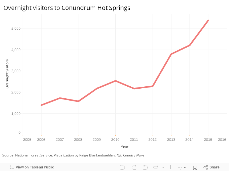
The Forest Service has been documenting problems with increasing overnight use in the area for over thirty years — and in the last decade, visitation of the hot springs has increased nearly four-fold, from just 1,395 overnight visitors in 2006 to 5,372 in 2015.

Under a new proposed management plan, if all goes well, Conundrum will go the way that so many over-loved federally-protected lands across the country may be heading: Starting next year, a permit system will limit the number of overnight visitors.

Though final numbers are still in the works, the new system will likely allow around 100 people per night to camp at the 36 compliant campsites in the Conundrum Valley. The restrictions, land managers hope, will address impacts to the area — but the move raises questions about how wilderness should be managed as visitation grows far beyond anything the Wilderness Act could have anticipated.

 The dirt road that leads to the Conundrum trail-head is lined with leafy aspens, tall pines, and NO PARKING signs. On a recent Saturday, cars were crammed in to the last sign. I carefully wedged my car into the only available space — and immediately watched a couple in a pickup truck pull in, find no spot and leave.

The current situation at Conundrum Hot Springs arose from the overall increase in people recreating on Colorado’s public lands — a trend that will almost certainly continue — and the swift publicity of photos on social media and in glossy magazines.

Schroyer said the internet has been “incredibly powerful” with places like Conundrum and Hanging Lake, which have become bucket-list destinations. She sees why people want to come — and they’re going to keep coming.

“This is a gorgeous, gorgeous area,” she said. “We just need to do a better job of managing that use.”

But so much use in a wilderness area puts land managers in a tough position: Managing wilderness goes against the very nature of wilderness, where natural forces are meant to reign.

“It’s almost an oxymoron to manage it,” Katy Nelson, wilderness and trails program coordinator for the Aspen-Sopris Ranger District, says. “The best thing that we can do for wilderness is exercise restraint.”

But places like Conundrum test the limits of that restraint.

“It’s hard because you want people to enjoy it, but you also want it to be protected,” Nelson says. “They’re kind of opposing forces.”

She sees trying to reconcile those forces as the biggest challenge of our era when it comes to wilderness protection.

“I know this is so cliché,” she adds, “but it is genuinely a conundrum.”

bear woodsThe reservation system for Conundrum is the first phase of a new management plan for the Maroon Bells-Snowmass Wilderness that Schroyer and her team have worked on for two years. If it’s successful, a reservation system for the Four Pass Loop, a popular backpacking route, will follow.

The plan is the result of careful documentation over the course of years, gathering the kind of data that really drives home the extent of the problems at Conundrum, such as the 344 “unburied poops” rangers packed out in 2015.

Amid soaring popularity, other places in the West are grappling with how to limit use: permit systems exist for areas of Canyonlands National Park, Rocky Mountain National Park, the Desolation Wilderness, and several more. A permit system for entry to Zion National Park is currently under consideration.

Already, six out of Colorado’s 44 designated wilderness areas, including the Indian Peaks Wilderness, either have or are in the process of implementing limited use permits.

Schroyer sees the plan for Conundrum and the rest of the Maroon Bells-Snowmass Wilderness as a potential model for other wilderness areas facing similar issues. If a place like Conundrum can rebound from such intense impacts, it will serve as a powerful example.

As Sloan Shoemaker, executive director of the Carbondale-based nonprofit Wilderness Workshop put it, “How do you manage to reach the expectations of people who go to a wilderness hot springs and end up at a rave?”

Rebecca Worby is an editorial fellow at High Country News.

SEE ALSO: The future could be bleak for our national parks

Join the conversation about this story »

Here's what Category 1, 2, 3, 4, and 5 labels for hurricanes really mean

$
0
0

a hurricane

The Saffir-Simpson scale of a hurricane's intensity is used to estimate potential property damage and coastal flooding caused by storm surge. The scale is determined by wind speed. Storm surge is an abnormal rise of water above the normal tide, generated by a storm.

Flooding from storm surge depends on many factors, such as the track, intensity, size, and forward speed of the storm and the characteristics of the coastline where it comes ashore or passes nearby.

Harvey was a Category 4 storm when its eye made landfall in Texas at around 10 p.m. Friday, but has since been downgraded to Category 1.

Category 1

Winds of 74-95 mph (120-150 kph). Storm surge of 4 to 5 feet (1 to 1.5 meters) above normal. Damage primarily to un-anchored mobile homes, shrubbery and trees. Some damage to poorly constructed signs and piers. Extensive damage to power lines and poles likely will result in power outages that could last a few to several days.

Category 2

Winds of 96-110 mph (155-175 kph). Storm surge 6 to 8 feet (1.8-2.4 meters) above normal. Some roof, door and window damage to buildings. Considerable damage to mobile homes, small watercraft, trees, poorly constructed signs and piers. Flooding of coastal and low-lying areas. Many shallowly rooted trees will be snapped or uprooted and block numerous roads. Near-total power loss is expected with outages that could last from several days to weeks.

Category 3

Winds of 111-129 mph (180-210 kph). Storm surge 9 to 12 feet (3 to 4 meters) above normal. Some structural damage to small homes. Mobile homes destroyed and large trees blown down. Coastal flooding destroys smaller structures and floating debris damages larger structures. Terrain lower than 5 feet (1.5 meters) above sea level may flood as far as 8 miles (13 kilometers) inland. Hurricane Katrina, the costliest natural disaster in U.S. history, was a Category 3 storm at landfall in 2005 after being a Category 5 in the Gulf of Mexico. At least 1,800 people died.

Category 4

Winds of 130-156 mph (210-250 kph). Storm surge 13 to 18 feet (4-5 meters) above normal. Wall failures and roof collapses on small homes, and extensive damage to doors and windows. Complete destruction of some homes, especially mobile homes. Power outages will last for weeks to possibly months. Major coastal flooding damage. Most of the area will be uninhabitable for weeks or months. Two 2004 storms were Category 4: Hurricane Ivan, which made landfall near Gulf Shores, Alabama, and Hurricane Charley, which hit the Florida Gulf Coast near Fort Myers. Charley killed at least 21 people and left thousands homeless. The total U.S. damage was estimated to be near $15 billion.

Category 5

Winds greater than 157 mph (250 kph). Storm surge greater than 18 feet (5 meters) above normal. Complete roof failure on many homes and industrial buildings. Smaller buildings and mobile homes blown over or completely blown away. Major damage to lower floors of all structures located less than 15 feet (4.5 meters) above sea level and within 500 yards (460 meters) of the shoreline. Massive evacuation of residential areas on low ground within 5 to 10 miles (8 to 16 kilometers) inland may be required. The last Category 5 storm to hit the United States was Hurricane Andrew in 1992. An estimated 250,000 were left homeless and the storm caused more than $20 billion in damage in the Bahamas, Florida and Louisiana. Fifty-five people were killed.

Source: National Hurricane Center

SEE ALSO: Incredible satellite photos show Texas before and after Harvey flooded the region

SEE ALSO: The crucial reason Houston officials didn't order evacuations before Harvey made landfall

Join the conversation about this story »

NOW WATCH: Incredible time-lapse footage shows the enormous number of lightning storms Hurricane Harvey had as it hit Texas

Hurricane Irma is now a Category 5 storm and could make landfall in Florida

$
0
0

hurricane irma path track forecast probability cone

  • Hurricane Irma has been gaining strength since Thursday and is now a Category 5 storm.
  • The National Hurricane Center's designated warning area includes the US Virgin Islands, Puerto Rico, and the Dominican Republic.
  • Two predictive models suggest Florida could fall in the storm's path, but it's too early to determine whether it will make landfall in the US.
  • Governor Rick Scott has activated the Florida National Guard in case the storm impacts that region.

A week after Hurricane Harvey made landfall, devastating Texas with torrential flooding, meteorologists turned their attention toward Hurricane Irma.

The storm formed off the coast of western Africa last week and almost immediately began barreling toward the Caribbean Sea. Irma officially became a named storm on Wednesday and was classified as a hurricane on Thursday. Since then, it has gained strength from the moisture of warmer Atlantic Ocean waters.

Since Monday, the storm has metastasized from a Category 3 hurricane into a Category 5 hurricane, according to the National Hurricane Center.

The Category 5 label means that parts of the storm's core have sustained wind speeds of about 175 mph. That's as powerful as a severe tornado, which can tear off roofs, level homes, toss cars, overturn trains, and uproot large trees. There's also a risk that a storm surge — the crest of water at the front of a storm and is created by powerful winds — may reach a height of 18 feet, though surge-height forecasts differ greatly among regions.

"Some fluctuations in intensity are likely during the next day or two, but Irma is forecast to remain a powerful Category 4 or 5 hurricane during the next couple of days," the NHC said in a public advisory on Tuesday morning. It also called Irma "an extremely dangerous" hurricane and advised that "preparations should be rushed to completion in the hurricane warning area."

Those warning areas now include the US Virgin Islands as well as Puerto Rico, where the storm could hit as early as Wednesday morning. The Dominican Republic, meanwhile, is under a hurricane watch; the country could get hit by tropical-storm-force winds on Wednesday evening, according to Tuesday forecasts.

Possible landfall in the US

Forecasters don't know yet whether Irma will make landfall in the US at all, let alone as such a powerful storm. But the latest computer models are not comforting — some suggest the storm could plow through many Caribbean islands and head into the Gulf of Mexico, while other models have Irma tracking up the East Coast.

Two of the most predictive models strongly agree that South Florida and possibly Miami may be in Irma's path. If this scenario plays out, tropical-storm-force winds could reach the Florida Peninsula as soon as Friday evening.

"It's way too early to say for sure if Irma is going to have any impacts on the United States, but anytime the forecast models are predicting a potentially strong hurricane headed northwest across the tropical Atlantic, I'd pay attention," Phil Klotzbach, a meteorologist at Colorado State University who specializes in Atlantic hurricane forecasts, previously told Business Insider.

To prepare for Irma's possible impacts, Florida Governor Rick Scott ordered all 7,000 members of the state's National Guard to report for duty on Friday morning.

"We do not know the exact path of this storm, but weather can change in an instant and while we hope for the best, we must prepare for the worst," Scott said in a statement.

A combination of conditions — including a warm tropical Atlantic, a weak wind shear, and a change from drier to wetter weather — made it easy for Irma to pick up strength, according to Klotzbach. The storm could put us far ahead of the average accumulated cyclone energy (a measure of the energy of tropical cyclone systems) for this time of year, he said.

Michael Ventrice, a meteorological scientist at The Weather Company (the group behind the Weather Channel and Weather Underground) told Business Insider on Thursday that Irma "could be the strongest hurricane of the year."

A busy hurricane season

Both CSU and The Weather Company predicted an unusually active hurricane season this year. Irma is already the fourth hurricane of 2017, though the average date of the fourth hurricane in a year is September 21. The peak of the season is around September 10.

Klotzbach said that half of the season's cyclone energy usually occurred in September, meaning major hurricanes are likely still to come. On Tuesday, in fact, a tropical storm named Jose formed east of Irma and could also make its way toward the Caribbean.

Big hurricanes are usually defined by their wind force, but as we saw with Harvey, which made landfall as a Category 4 hurricane but caused most of its damage with heavy rain, the number doesn't always accurately predict a storm's impact.

Saffir-simpson hurricane scale

SEE ALSO: Incredible satellite photos show Texas before and after Harvey flooded the southeastern region

DON'T MISS: The crucial reason Houston officials didn't order evacuations before Harvey made landfall

Join the conversation about this story »

NOW WATCH: Incredible time-lapse footage shows the enormous number of lightning storms Hurricane Harvey had as it hit Texas

How to track the path of Hurricane Irma — which could soon hit the US

$
0
0

hurricane irma noaa goes satellite infrared rbtop sept 5 2017

Since Thursday, Hurricane Irma has been gaining strength and is a Category 5 storm as of Tuesday.

That means parts of the hurricane's core have sustained wind speeds of at least 175 mph, violent enough to destroy homes and overturn trains. There's also a risk that Irma's storm surge — a crest of water formed before a storm by powerful winds — may reach a height of 11 feet above a typical high tide, though storm-surge levels vary by location.

The National Hurricane Center has issued warnings for the US Virgin Islands, Puerto Rico, and the Dominican Republic, where Irma could strike as early as Wednesday morning. Some hurricane experts say the US Gulf region and East Coast — from Florida to Maine — should prepare.

Several official weather agencies and experts — some known as hurricane hunters— are tracking the storm.

The two largest US organizations tracking the storm, the National Oceanic and Atmospheric Administration's NHC and National Weather Service, are providing live updates on their sites and Twitter.

Using data from drones, satellites, radar, and buoys, these organizations are tracking Irma's possible path, wind speeds, heat, and rain levels.

Below are some other reputable meteorologists to follow on Twitter who are continually sorting through NHC, NWS, and NOAA data:

Alex Pier, a YouTube user, has also made a playlist of webcams livestreaming several areas where Irma could hit. These may show the storm on the ground level.

SEE ALSO: Hurricane Irma is now a Category 5 storm and could make landfall in Florida

Join the conversation about this story »

NOW WATCH: An expanding sinkhole in Florida has swallowed 7 homes

Hurricane Irma looks monstrous in a new video recorded by the International Space Station

$
0
0

hurricane irma

Astronauts in space see the world differently than the rest of us, and at no time is that more apparent than when monster storms whirl across the ocean and threaten human civilization.

The International Space Station flew over Hurricane Irma on Tuesday, just as the storm threatened Caribbean Islands and possibly South Florida with near-record-breaking winds. (Though as Hurricane Harvey showed, torrential rainfall can be just as devastating.)

Irma was a Category 5 storm as of Tuesday with maximum sustained winds of 185 mph. Some gusts have exceeded 215 mph, making it one of the most powerful Atlantic hurricanes ever recorded.

Below is a video of the tempest that NASA just recorded using cameras positioned outside the ISS.


A few seconds into the video, one of the cameras zooms in on the eye of the hurricane. Meteorologists say Irma's eye has a taken on a "stadium effect" because its eye-wall of clouds towers so high.

There's also a moment where the silhouette of a Russian Soyuz spacecraft — currently NASA's only ride to and from orbit — drifts in front of the storm. (The spaceship stays attached to the ISS until crewmembers return to Earth.)

Irma, which the National Hurricane Center has called "potentially catastrophic" storm, appears to move quickly, though it's really the space station that's in motion: The ISS orbits Earth at a speed of about 17,500 mph to stay in continuous free-fall around the planet some 250 miles above the ground.

Space station cameras tooled around to keep Irma on-screen in the nearly 5-minute-long clip. Yet Irma, which was more than 400 miles wide at the time, seems to barely fit inside the frame.

Irma is expected to begin hitting Puerto Rico Wednesday night, move into the Dominican Republic and Haiti on Thursday morning, and head to to Jamaica Friday morning. Florida and Cuba could see the storm by the weekend, but that's too long from now for weather models to accurately predict Irma's location or strength at that point.

SEE ALSO: Hurricane Irma is now a Category 5 storm and could make landfall in Florida

DON'T MISS: How to track the path of Hurricane Irma — a storm that could soon hit the US

Join the conversation about this story »

NOW WATCH: Incredible time-lapse footage shows the enormous number of lightning storms Hurricane Harvey had as it hit Texas

NASA footage shows a 'potentially catastrophic' Hurricane Irma that could make landfall in Florida

$
0
0

A week after Hurricane Harvey made landfall, devastating Texas with torrential flooding, meteorologists are now intently focused on Hurricane Irma's dangerous growth and projected path.

The storm formed off the coast of western Africa last week and almost immediately started barreling toward the Caribbean Sea. Irma officially became a named storm on Wednesday and was classified as a hurricane on Thursday. Since then, it has gained strength from the moisture of warmer Atlantic Ocean waters.

From Monday through Tuesday, the storm metastasized from a Category 3 hurricane into a Category 5 hurricane, according to the National Hurricane Center.

Join the conversation about this story »


Florida officials are issuing evacuation orders as Hurricane Irma approaches with 185-mph winds

$
0
0

Hurricane Irma Florida

Hurricane Irma continues to strengthen as it barrels towards Florida, and officials are already ordering evacuations from areas likely to be hardest-hit if the storm makes landfall. 

Irma — one of the strongest storms ever recorded in the Atlantic — is a Category 5 hurricane with maximum wind speeds of 185 miles per hour. The storm, which was creeping towards the Caribbean island of Antigua as of Tuesday afternoon, comes just a week after flooding caused by Hurricane Harvey destroyed buildings and neighborhoods in Houston. 

Florida Gov. Rick Scott activated the Florida National Guard on Tuesday, calling on all 7,000 members to report for duty on Friday morning, the Orlando Sentinel reports

Scott also asked President Donald Trump to declare a state of emergency for Florida to free up federal funding for evacuations and flooding infrastructure.

“Our state emergency management officials are working with our federal and local partners to prepare for any potential impacts from this dangerous storm,” Scott said in a release. “And it is crucial that we have access to every available resource to protect our families and communities.”

Florida Sen. Marco Rubio also issued a warning about the hurricane on Twitter Tuesday afternoon: 

Models are predicting that Irma could hit Florida by Saturday or Sunday, though forecasters can't be certain of how strong the storm will will be or where it will be five days out. 

Officials in Monroe County, where the Florida Keys are located, ordered a mandatory evacuation for tourists by Tuesday morning and will order mandatory evacuations for all residents on Wednesday morning. The county's schools will close on Wednesday, the Sentinel reports.

The mayor of Miami-Dade County, Carlos Giménez, warned on Tuesday that officials could ask residents to evacuate ahead of the storm as early as Wednesday. Residents with disabilities and special needs will be evacuated on Wednesday morning, and Giménez urged residents to have at least three days of food and water on hand, reports The Washington Post

"This hurricane is far too powerful, poses far too great a threat for us to delay actions any further," Giménez said, per The Post. 

Miami International Airport has also issued a travel warning ahead of the storm, while officials at Orlando International say they're monitoring the storm and will decide whether to relocate planes and move equipment off the runway. Airlines including American, JetBlue, Spirit, and Air Canada are issuing waivers for travelers to change their itineraries to a number of Florida airports for no fee. 

Hurricane warnings were also issued for 12 island groups in the Caribbean, including Puerto Rico and the Dominican Republic, with residents urged to evacuate ahead of the storm. 

SEE ALSO: Hurricane Irma is now a Category 5 storm and could make landfall in Florida

Join the conversation about this story »

NOW WATCH: NASA footage shows a 'potentially catastrophic' Hurricane Irma that could make landfall in Florida

A meteorologist says climate change will make it more expensive to fly – and it's all because of turbulence

$
0
0

Climate change could make flying more expensive in the future and it's all down to increased turbulence, according to Paul Williams, a Professor of Atmospheric Science in the Department of Meteorology at the University of Reading. 

He said: "Invisible turbulence in the atmosphere is generated by what atmospheric scientists call a wind shear. It means that the higher up you go, the stronger winds blow.

"So for example, if you’ve ever climbed the Eiffel Tower, you’ll know that when you’re on the ground it’s usually not very windy but as you climb up and go higher, the winds speed picks up. That’s a wind shear.

"That effect increases all the way up to 10 kilometres in altitude where planes fly and it is wind shears, in the atmospheric winds that cause clear-air turbulence, and we have evidence that the jet stream is speeding up because of climate change.

"So that’s increasing the wind shear, increasing the instabilities and causing more turbulence to break out.

"There are a number of different ways in which turbulence costs the airlines money and of course they have to pass those costs on to the passengers. The most obvious way is injuries to passengers, flight attendants and crew. We know that there are thousands of planes every year in the USA alone encountering severe turbulence which is strong enough to hospitalise people. 

"If you add up all of these costs, the total cost of turbulence to the airlines is estimated to be up to $500 million a year in the USA alone and if you extrapolate that figure globally, we’re easily talking into the billions of dollars a year as being the cost of turbulence to airlines which of course gets passed on to passengers."

Produced by Jasper Pickering. Filmed by David Ibekwe. Special thanks to Joe Daunt.

Join the conversation about this story »

The 10 strongest hurricanes ever to hit the Atlantic Ocean

$
0
0

irma satellite

Hurricane Irma is slamming the Caribbean as a category 5 storm

Irma's recorded maximum wind speed hit 185 mph on Wednesday, with some gusts of wind moving as fast as 215 mph.

That makes the storm one of the most powerful ever to hit the Atlantic basin. 

The categories on the Saffir-Simpson Hurricane Scale are determined based on wind speed, but that's not the only element of a hurricane that causes damage. Flooding, a metric that the categories don't take into account, can often become a costly problem, as was recently seen when Hurricane Harvey flooded parts of Texas and Louisiana. 

To put this year's storms into perspective, here are 10 hurricanes that topped the charts as the strongest in the history of the Atlantic Ocean, based on wind speed and pressure. 

SEE ALSO: Irma, the most powerful Atlantic hurricane in recorded history, is slamming the Caribbean — and Florida is now in the crosshairs

DON'T MISS: The 15 most destructive hurricanes in US history

Hurricane Katrina, 2005 - 175 mph

Hurricane Katrina made landfall as a Category 5 with winds up to 175 mph near Miami, before striking Louisiana as a Category 3 storm. Katrina was the third deadliest hurricane in US history, with more than 1,200 deaths. It caused $108 billion in damage, making it costliest hurricane the country has ever seen.


Hurricane Andrew, 1992 - 175 mph

About 25 years ago, the Category 5 Hurricane Andrew ripped through Florida with 175-mph winds, leaving millions without power and many neighborhoods completely destroyed. The response was so problematic that it led to major changes within the Federal Emergency Management Agency, according to USA Today


Hurricane Camille, 1969 - 175 mph

Hurricane Camille formed in the Gulf of Mexico and hit Mississippi as a Category 5 storm. Camille caused more than 256 deaths and is considered one of the most intense hurricane to hit the US based on its pressure, which was measured at 900 millibars. (The more intense a hurricane is, the lower its pressure.)


See the rest of the story at Business Insider

The 16 most destructive hurricanes in US history

$
0
0

a hurricane

Hurricane Irma, one of the most powerful hurricanes ever recorded in the Atlantic Ocean, has started slamming some Caribbean islands as a category 5 storm

Irma's path suggests it could hit Florida over the weekend, and Florida Governor Rick Scott has told people to "prepare for the worst."

The storm is the latest in an already catastrophic hurricane season, which lasts from June to the end of November for the Atlantic Ocean. It follows Hurricane Harvey, which devastated parts of Texas including Houston last week and caused damage estimated to be worth more than $100 billion.

The US has seen plenty of catastrophic and costly storms throughout its history, with single events causing billions of dollars in damage. Here's a look at some of the most devastating, costly storms ever to hit the US.

SEE ALSO: Why your picture of the eclipse might have a little blue crescent hidden in it

DON'T MISS: Hurricane Harvey could devastate parts of Texas — here's what you need to know

Hurricane Opal, 1995: $5.1 billion

In 1995, Hurricane Opal devastated the Florida panhandle before hitting Alabama and Tennessee. The storm caused $5.1 billion worth of damage.  


Hurricane Isabel, 2003: $5.3 billion

Hurricane Isabel, the costliest hurricane of the 2003 season, made landfall in North Carolina, impacting much of the Outer Banks. It caused $5.3 billion in damages. 


Hurricane Floyd, 1999: $6.9 billion

Hurricane Floyd was a catastrophic storm because of the rain it brought. The downpours caused extreme flooding from North Carolina on up the East Coast as the Category 2 storm traveled north.


See the rest of the story at Business Insider

Hurricane Irma could make landfall in Florida — here are the latest updates on the massive storm

Viewing all 2972 articles
Browse latest View live


Latest Images